I’m off again! This time I’m attempting the Coast-to coast walk popularised by Alfred Wainwright, the great fell walker of the 1970s. I set off on May 6th 2015, from St Bees on the coast of Cumbria, heading for Robin Hood’s Bay on the North Sea Coast.
In case anyone who followed this blog would like to follow me on the Coast-to-coast, I thought I would let you know by posting here.
The link below will take you to the new blog, where you will find the “Day 0” post. If you would like to receive daily email notifications of the latest posts, please add your email address at the top of the sidebar on the right of the “Day 0” post, click on the link, and follow the instructions.
It will be great to have you along….
http://corrigendus4.blogspot.co.uk/
Wednesday 29 April 2015
Saturday 12 April 2014
Day 8: Cley-next-the-Sea to Cromer
| Weather: Sunny and warm with a light, following wind |
| Distance covered today: 23.2km ( 14.4mi) |
| Last night's B&B: Cookes of Cley |
| % Complete: Cumulative distance: 100%: 166.4km |
| GPS satellite track of today's route: Day 8 (click!) |
Peddars Way and the Norfolk Coast Path is a walk for the cognoscenti. True, it is in the main flat, (though today's walk provided something of a surprise with a slight sting in the tail), short (the shortest to date) and the weather is likely to be as good as may be experienced anywhere in these islands. The going is generally very good, though again, today was in part an exception. The path is very well maintained (storm surges permitting) and signed. However, compared to what is on offer on any of the other national trails in my experience, it is just a bit ho-hum.
That is, unless you are interested in birds. I had vaguely realised that this was a bird-watchers paradise, but I hadn't realised the extent of it. As an example, the sighting of a North-American white-crowned sparrow in 2008 attracted thousands of visitors, and their charitable donations paid for restoration of a stained-glass window in a local church, where the famous sparrow is now depicted. I remember on Hadrian's wall, describing the somewhat intellectual walkers with their reference books and their high foreheads. I contrasted them with the Pennine Way walkers (the paths overlap at this point), with our Neanderthalic receding brows and our wild, staring eyes. Indeed, the walkers of Norfolk Coast are just as distinguishable! They too have their reference books, and the quiet and unobtrusive manner of the intellectual nature lover. The average age is far higher, and from the conversation, these people visit multiple times. There are many second homes in the pretty villages near the coast, occupied, I understand, in the main by birders. Cley Marshes is one of the foremost bird reserves in the country and the path along the East Bank has been called 'the most famous bird walk in Britain'. Of course hardly any of these people actually walk the entire coastal path, let alone the lonely Peddars Way; on my travels, I met only one person doing so.
The other fascination is the constant shifting and erosion of the coast. On my way, I learned that the Environment Agency, the National Trust and locally the Norfolk Coast Partnership have changed their policy with respect to coastal erosion. The impact of climate change is such that the country can no longer afford to defend against all coastal erosion, and so a choice must be made. The authorities are defining areas where a determined effort will be made to resist the sea, and for the rest, the sea will just be left to get on with it. On the North Norfolk coast, there is a growing acceptance of the area as a "naturally functioning coastline". Of course, there will be losers, and the policy will always be controversial. No doubt, the politicians will meddle with it on occasion, as they did this year on the Somerset Levels, but a walk along this coast shows quite clearly that the policy is not just sensible. There just isn't a credible alternative. Even the spectacle of houses falling into the sea is overblown by the media: the Environment Agency estimates that "200 homes are at risk of complete loss to coastal erosion in the next 20 years". This is serious, especially for the owners, but given that there are 20-25 million houses in the UK, it is not critical. On the other hand, the white cliffs of Dover will stay white and more topically, the beautiful Hunstanton Formation will remain magnificently red!
The constant shifting of the coastline has uncovered other important finds, which include the bones and teeth of hippopotamus, hyena and even the Etruscan rhinoceros! In 1990 the 85% complete skeleton of a 5 metre tall elephant was discovered and in 2005, flint flakes worked by early man were found that push back the date of the first recorded human activity in Britain to 840,000 years ago.
Not of course that I discovered any of these things, though I was told, interestingly, to keep my eyes open for the flint flakes, just as I had been in Pembrokeshire. The last day of my walk was not without its challenges, the most notable being a 5 mile (8km) hike along the shingle beach from Cley Eye to Weybourne Hope. This was more challenging in places than walking in soft sand, and I sustained the only injury of my trip; a pulled muscle on my shin, but the sound of the sea and the fact that in places I had the entire coastline to myself was great consolation (no-one else was stupid enough to trek along the coast!). I had a delightful tea-break in an ancient tea-room in Sheringham, populated by very old people, one of whom, wearing very dark sunglasses indoors for some reason, accosted me and explained her war in London, where as a teenager, she had romped amid the bombed-out buildings and watched the nightly pyrotechnics, to the great displeasure of her parents, but with numerous friends and relations. Her parents had moved out of London to Coventry, but when that was bombed, they decided to return to London, because one might as well be happy and one was at risk everywhere!
The final stretch included an unexpected climb to the highest point in Norfolk, albeit only 105 metres (350 ft) through wooded plantations amidst numerous caravan parks, followed by a gradual descent into Cromer and a somewhat ant-climactic end of walk. I had expected a plaque or something on the Cromer Pier to signal the end, but when I spoke to the woman running the lifeboat centre at the end of the pier, she knew nothing about it; hadn't even heard of the walk! Eventually, I found a lamppost with a national trail acorn on it showing the distance to Hunstanton, and I decided that would have to do. Meanwhile, poor Veronica had been held up in traffic, so I pounced on a passing stranger, asked her to take my picture, and headed for yet another tea-room.
The blue numbered pushpins show the start and end of each days walk
Even the one wet day was really only drizzly for the first hour. Walking conditions could not have been better and I enjoyed a following wind the entire trip
I suspect the GPS satnav slightly overdoes these altitude stats, but this is what it says!
This is more accurate. The length of the path is about the same as the Cotswold Way
Ditto in miles

A WW2 turret near Cley. There was evidence all over of coastal defences, though most are disappearing as the coastline changes

The start of the shingle shoreline

I met a family composing a birthday card on the beach amidst great hilarity and industry. A photo would be taken by smartphone camera and sent to the recipient elsewhere

The shingle banks; each layer shaped by a storm. Not easy walking!

"He who would old England win, must at Weybourne Hoop begin". Apparently the shape of the coastline here allows deep-draught boats to anchor close inshore, and this has bred invasion scares for centuries, along with much military presence, from Elizabethan times onwards. The Muckleburgh Military Collection is now one of the largest private displays of military equipment in Britain

Beyond Weybourne, the cliffs start to rise for the first time since Hunstanton, and the evidence of constant erosion is clear

The path used to run in front of this house; now it has been diverted to the rear. The house is still occupied but it must be one of the 200 houses in Britain threatened by the sea.

Erosion taking recent chunks out of the coastal path, Do not approach the edge!

An African squatter camp in England? No, those are huts on allotments!

A thin blue line separates the golfers from the walkers. (Actually, it is just the out-of-bounds marker!)

The North Norfolk Railway, a preserved steam railway, connecting Sheringham with Weybourne and Holt. The sound of its whistle was so redolent of my youth, on the way to school in Grahamstown.

In Sheringham, determined efforts to shore up the coastline against the sea, using great slabs of highly reinforced concrete, in pursuance of the new policy. Here we stand!

The first swimmers I have seen all trip. They looked frozen!

This was the old lady who told me about her war years in that strange little tea-room

These Shetland Ponies are in a horse sanctuary; they looked well cared for, but are nevertheless a reminder of the stupid sentimentality that pervades the attitudes towards horses in this country. Old horses should be put down and eaten. I agree with Veronica and Princess Anne!!

Just visible, shimmering on the horizon, the Sheringham Shoal Wind Farm, 317 MW of capacity (10% of the capacity of a large coal-fired plant), but almost unobtrusive in its place

Country walking through the woods to Cromer

Cromer Church - a cathedral to any other!

No plaque at the end of the pier, just a funny photo op. In retrospect, I should have stuck myself in the middle hole!

The elegant Cromer Pier. Too bad about the seaside tat!

At least the Hotel de Paris looks the part!

At last I found a lamppost indicating the start of the trail, because it is indeed 47 miles by trail to Hunstanton

So I had a passer-by take a snap. Job done....
Wednesday 9 April 2014
Day 7: Wells-next-the-Sea to Cley-next-the-Sea
| Weather: Sunny and warm with a light, following wind |
| Distance covered today: 18.5km ( 11.5mi) |
| Last night's B&B: Armeria Bed & Breakfast |
| % Complete: Cumulative distance: 86.8%: 143.2km |
| GPS satellite track of today's route: Day 7(click!) |
My anxieties about the surge-damaged coastal path proved
groundless. I met a couple of posh
Londoners in a café in Blakeney, and my concerns about the path came up in
conversation. They assured me that they had just come along the affected bit of
path in the opposite direction, and though there were signs and fences,
everyone was just ignoring them. In the
event the path has had extensive repairs, with new boardwalks installed in
places and all the earthworks repaired. I can only imagine that the path remains
closed because some jobsworth in ‘elf and safety hasn’t had the time to get up
here from London to give the works the thumbs up. I met some National Trust
workers along the way, and even they didn’t object to my presence or that of the
hordes of holiday-makers traipsing illegally along the trail. It is interesting how mass action seems to
confer legitimacy on what is clearly illegitimate behaviour.
I was thinking about this and relating it to other examples,
like the current mass action of the politicians against the BBC. First there
was this move that transferred the cost of supporting the World Service from
the Foreign Office to the Beeb. Then,
lately, there has been this multi-party supported move to decriminalise
non-payment of the licence fee.
Although it means so much more to me, I suppose there is an
argument that the BBC is just like any other utility and I don’t get charged in
the criminal courts when I don’t pay my gas bill. The difference is that if I
don’t pay my gas bill, the gas man cuts off the gas, but there is no way the
BBC can prevent me from continuing to watch telly if I don’t pay my licence. Millions of people will simply stop paying,
and even if the Beeb prosecutes some of them in the civil courts, the overhead
involved and the non-payment of fines will overwhelm the system. This will
force the BBC to move to a set-top box subscription service, so that they can
withdraw service for non-payment. That will make it have to fight for customers
in direct competition with the likes of Sky, which is what Murdoch wants, and
there lies American TV. I’m not arguing
that the Americans don’t make some high quality TV productions; they do, but
anyone who has lived there knows that in the main, the dross that is produced
is stultifying in the extreme. As for
radio, the subscription option isn’t open, so the only answer is advertising,
and that prospect is simply horrifying.
Even the transfer of the costs of the World Service from the
Foreign Office to the BBC is highly questionable. When I lived overseas, I used hungrily to
listen to the Beeb, whether it was to receive news of the latest coup in an
adjacent country or the latest score in the then First Division. I understand
only too well what the World Service meant to the residents of dictatorships
across the world from Mandela to Aung San Suu.
The question though, is who should pay for it? The motivation for the
World Service in the first place was to spread Western values of democracy and
the rule of law, and equally to promote Britain in the eyes of the world as a
beacon of those liberal values. Apart from the recipients of that vital
information, the main beneficiaries of the ensuing goodwill were presumably the
citizens of the UK. It seems therefore
that the tax system rather than BBC licence fees should bear the cost (it’s
also a lot less regressive). In fact it
seems to defy logic that when the politicians are trying to marginalise the BBC
into being just another subscription competitor in an open market, they are
simultaneously saddling it with the cost of propagating the values of the UK
body politic to the wider world! Am I
alone in perceiving this immense contradiction!
I suspect that the answer lies in the political ravages of
the Murdoch press, especially after Levison. Politicians need Murdoch support
and that of the press in general. The
press recognise that unless they make the running now, they will disappear
under the onslaught of the internet. The
BBC remains a high quality, ‘free’ competitor (you pay the licence for entertainment
and you get your news for free!), and it is much more vulnerable than the
internet. An unholy alliance develops
between the press and the politicians to sink the Beeb. I probably won’t be around for the last
rites, but I can guarantee that when it happens, the world will have lost one
of the greatest institutions in the history of mankind.
On the note of not being around, I suppose I have to ‘fess
up! I have been receiving all sorts of
messages on the quiet back channels, asking me why on earth I am doing this
short, sharp walk, when I had intended to do the Coast-to-Coast instead? They
are also questioning the slightly dark content of this blog, compared to its
exultantly gleeful predecessors. The reason is that I am going into hospital
for a serious operation at the end of the month. My prostate cancer has
returned and there is a small chance that by operating now, the consultant may
be able to remove the cancer using a robotic technique. There are serious risks
of morbidity and even mortality associated with the operation, given all the radiotherapy
and HIFU (high intensity focussed ultrasound) treatment I have had in the past;
but there is also a chance that it might work.
After much discussion in the family, and despite the risks, I have
decided to go ahead. Marion is coming
back from the US to hold my hand and Veronica and Mazzi will be staying with
Anna in London to cheer me on. The operation will be performed at the Royal
Marsden in London, so I couldn’t be in better hands all round.
At least after this little gallop, I’ll be fighting fit for
the op! Tomorrow evening, I’ll meet my
ever-suffering and always helpful Veronica at my final destination, Cromer. Her welcome presence will, as usual, delay the last post until we have returned home.
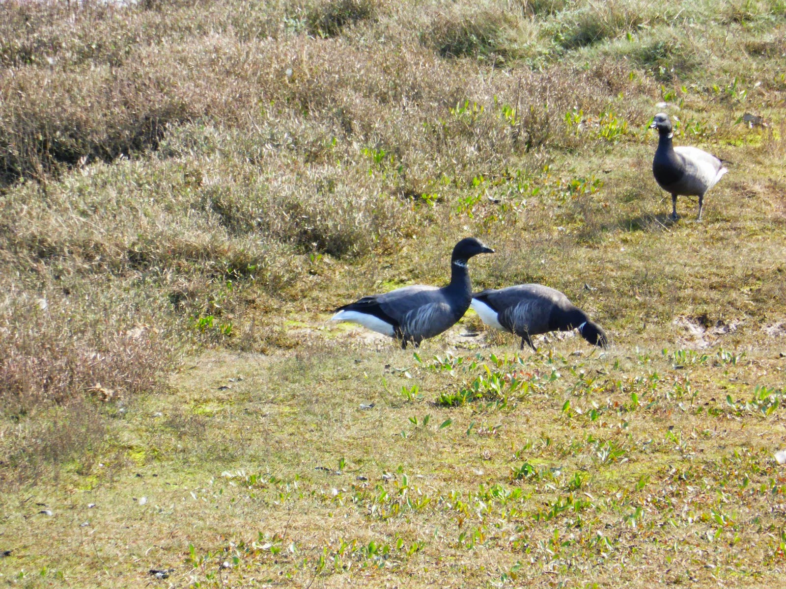
Brent geese in their thousands on the salt marsh

Unusually, a path through thick undergrowth

The salt marsh is extensive and reminiscent of the moors

Black-headed gull? (I thought it was more exotic!)

The walking was very comfortable, over springy marsh grass

Vessels sailing on dry land

The English will put anything in a sandwich!

Holiday walkers on the sea wall

Petronella marooned against the sea wall after the storm surge. With water now miles away, it won't be easy to float her

The Blakeney Hotel

An attractive street in Blakeney

Another vessel cast high and dry by the surge, but a different generation!

This is the life. I'll lie here on the banks of the sea wall looking at birds through my binocs, while you just lie there!

The so-called "closed" coastal path. People just ignored the sign, pulled down the fence and went for it. I followed them, I'm afraid! The path was fine....

The Cley windmill
Tuesday 8 April 2014
Day 6: Brancaster to Wells-next-the-Sea
| Weather: Partly sunny with gale force Westerly |
| Distance covered today: 22.3km ( 13.9mi) |
| Last night's B&B: The Bays Guest House |
| % Complete: Cumulative distance: 76.2 %: 124.7 km |
| GPS satellite track of today's route: Day 6 (click!) |
Although not scenically spectacular, today’s walk was by far
the most interesting of the trip to date, and worth making a special effort to
do it, even if one has no intention of doing the whole thing. I would also say that for birders,
particularly those interested in seabirds, this leg is a must. Vast numbers of
many species of birds were making use of the salt marshes on the seaward side
of the sea defence barriers. I don’t
even know whether this is a good time of year to view them? Of course I know as much about birds as I
know about wild flowers, which isn’t helpful, and I had neither binoculars, nor
a bird-book. What’s more, my little
compact camera is no match for the proper equipment required to do these guys
justice. Perhaps the only downside of
the day was that given the birds, there were indeed lots of birders, weighed
down with expensive equipment and presumably resentful of my lack of stealth as
I powered along the track amidst a sea of flapping wings and alarm cries as the
birds headed for the hills, or more likely, Scandinavia.
I say the birds were mostly on the seaward side of the defences,
but that wasn’t always true. In at least
three places, I saw evidence of recent emergency repairs to breaches in the sea
wall. During the recent floods, most
media attention was focussed on the other side of Britain, particularly on the
Somerset Levels, the coast of the South West and the Thames. Preceding those crises, there was a
confluence of circumstances which threatened coastal communities in East Anglia
and brought back memories of the fatal floods of 1953 when hundreds of people
were killed, including 60 between King’s Lynn and Hunstanton. Sea
defences burst in more than 1,000 places and thousands of people were
displaced.
The problem occurs at a time of seasonally high spring
tides, when there is a very strong depression over the North Sea driving vast
volumes of water down towards the bottleneck of the English Channel, amidst
huge waves and high winds. Following
that tragedy, East Coast defences were greatly strengthened and indeed, the
Thames Barrier was eventually built to prevent London from flooding. The problem recurred in December 2013, and
while everyone was expecting the worst, the defences held for the most part and
although two people were tragically killed and a house or two fell into the sea
as a result of coastal erosion, the media caravan moved on in time to the less serious
floods in the West.
The Norfolk Coastal Path website had warned me that the trail
had been compromised in places by the floods and I assumed that these would be
where the sea walls and the trail coincided. (I was informed that repairs would
be more or less complete by Easter, so I decided to take the risk. As it turns
out, I was wrong. Tomorrow’s walk is compromised and I’ll have to find another
route after I post this blog!). Of
course, once the wall has been breached and the sea has rushed landwards,
nothing much can be done until the flood is over, by which time the landward
side is under water. Fixing the sea wall at this point means that the water can’t
flow back to sea when the tide recedes. The incongruous result is that viewed
from the sea wall, all plains on the landward side appear waterlogged, while at
low tide, the salt plains on the seaward side appear quite dry! The birds
probably appreciate this, even if everyone else, especially the farming
community, doesn’t!
The sea walls are more interested in height above sea level
than in straight lines, so my progress today was via a delightfully meandering path
that sometimes even, rather frustratingly, doubled back on itself, following
the contours of the coastal plains and their disruptive rivulets. The effect
was a constantly changing perspective, of subtle browns, greys and the odd
green field on the landward side. All of a sudden, the path made a bolt for the
sea; the earthworks turned to boardwalks, the dunes were breasted and I walked
a delightful 5km (3mi) along a broad, flat beach, with gale-force winds pushing
me along from behind and the sea frothing away merrily on my port side. There was hardly a soul on the beach, and
those I saw were as exhilarated as I was!
Then again, it all changed as I approached my destination
and was greeted by the holiday attractions of a coastal resort, with its usual
complement of sullen and bad-tempered families, out with the kids at half-term,
with everyone hating the weather, each other and life in general. Admittedly the wind was very strong and
bitterly cold, and as I have noted before, one gets used to these things over
long walks, but get out of your air-conditioned Beemer, and the blast is enough
to set your teeth on edge, especially when the kids are screaming, and the
in-laws are asking whose idea this was anyway! And so they all head for the
tacky attractions of the resort, because there isn’t anything else to do!
As it happens, Wells-by-the-Sea is a moderately attractive town,
with an extant fishing fleet and the B&B I’m staying in is very
comfortable. My mood this evening was very much improved by two encounters. The
first was with the Wells Carnival Committee.
I was sitting in the pub, preparing my data, minding my own business and
all of a sudden the committee descended. I couldn’t help overhearing the proceedings. There was that rather formal, slightly
bureaucratic approach to meetings so redolent of volunteer committees of
enthusiastic amateurs. Minutes were formally read, the treasurer’s report was provided,
and someone offered to get drinks from the bar. After the initial awkwardness,
someone cracked a joke and they all erupted. All discipline was lost and a
party ensued. It could have been off a
script from the Archers! I was hugely
amused!
I went to the loo, and was accosted by a fellow who, seeing
my jacket, wanted to know if I was “off a boat”. He told me that he skippered a “smack”, and
they had shipped anchor this afternoon, but when he reached the “bar” and saw
the size of the seas in that gale force westerly, he turned tail and repaired
to the pub instead; he wasn’t sure he had enough draught in that tide. He had
that wonderful estuary marine accent that convinced me he came from the East
End and so he did. He also told me he
had walked the Pennine Way, and when I explained my exploits he tried very hard
to settle me in. I could see where it was going, and extracted myself on what
for him was a lame excuse; the Chelsea game!
Thank goodness I did, because I might not otherwise have
been capable of navigating my way around the breached flood defences tomorrow!

Eek! I don't have any tide tables!

Not to worry guv, no water!

But there had been a lot, and recently!

Well, not on my land anyway! (There are numerous paths from the harbour to the main road, where any number of animals could be landed. This little Englander is nevertheless doing his duty, and he was of course flying the flag! It is visible in the background.)

An Oystercatcher!!!!

I have absolutely no idea!

One of three breaches in the sea wall that I came across today that have been recently repaired...

So that the standing water is on the landward side....

And at low tide, the seaward side seems quite dry!

A working windmill, but it wasn't working in today's gales

A roller-coaster path over a destoned field

My motto, at last!!

A squall looked as if it would catch me. It missed!!

Heading for the dunes on the sea wall....

Which then turned into a boardwalk.....

And finally I reached the dunes themselves; shades of Betty's Bay....

And an angry sea!

Holiday makers, yuk!

By the hundreds.....

These boats service the offshore turbines

And so to the traditional (almost) fishing port of Wells-by-the Sea

Where they don't like the Department of Fisheries and Rural Affairs! (Fishermen's Friends are also a brand of strong peppermints!)

The fishermen's working boats
Subscribe to:
Posts (Atom)